
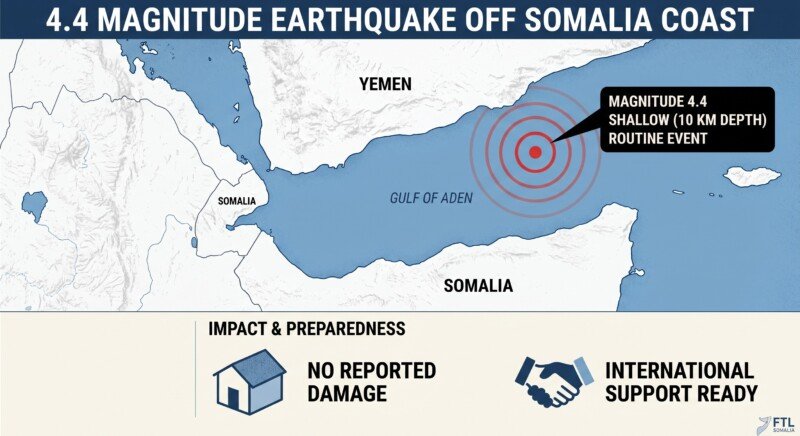
MOGADISHU — A magnitude 4.4 earthquake was recorded early Tuesday morning in the Gulf of Aden, approximately 186 kilometres north-northeast of Caluula in Somalia’s Bari region.
The United States Geological Survey (USGS) reported the earthquake occurred at 00:11 UTC, which corresponds to 03:11 local time. The focal depth was recorded at 10 kilometres, making it a shallow earthquake that can produce stronger surface shaking than deeper events of similar magnitude .
The earthquake registered a significance score of 298 on the USGS scale, which remains below the threshold of 600 that the agency uses for its significant-earthquake list. The ranking combines magnitude with available “Did You Feel It” responses and PAGER alert level, and is not a direct measurement of damage .
Location and Regional Context
The epicentre was located at coordinates 13.5996, 51.1906, placing it in the Gulf of Aden, the maritime corridor between Somalia and Yemen. The nearest recorded settlement in earthquake databases is Kilmia, approximately 72 kilometres east-northeast of the epicentre .
The Gulf of Aden is a seismically active zone where the Arabian and African tectonic plates interact. The movement of these plates generates pressure beneath the earth’s surface, which occasionally results in earthquakes. This geological activity makes the region prone to seismic events, though most are of low to moderate magnitude.
The earthquake is part of a pattern of seismic activity recorded in the area in recent months. According to earthquake monitoring databases, 15 earthquakes of magnitude 4 or above have been logged within roughly 200 kilometres of this epicentre. The strongest was a magnitude 6.0 event near Caluula on 27 August 2026, which released approximately 251 times more energy than Tuesday’s earthquake, as reported in FTL Somalia’s coverage of the August earthquake .
That August event, which struck approximately 145 kilometres north of Caluula at a depth of 10 kilometres, was described by USGS as the strongest earthquake to hit that part of Somalia in over 20 years. The USGS PAGER system issued a Green alert, indicating a low likelihood of casualties or significant economic losses, and no damage or injuries were reported .
Tsunami Risk and Response
The USGS record does not carry a link to National Oceanic and Atmospheric Administration (NOAA) tsunami information. This field is not an all-clear and does not state whether a tsunami occurred. A damaging tsunami would be less likely because at magnitude 4.4, the earthquake falls below the magnitude 6.5 threshold that generally applies before a submarine earthquake displaces enough water to generate a damaging tsunami .
No casualties or structural damage have been reported in connection with the earthquake. The lack of reports from the public, with zero “Did You Feel It” responses recorded, suggests the earthquake may not have been widely felt on land .
Seismic Preparedness in Somalia
Somalia has taken steps in recent years to strengthen its disaster preparedness framework. The government introduced a Multi-Hazard Early Warning System under the global Early Warnings for All framework, collaborating with the United Nations Development Programme and the Green Climate Fund. The initiative aims to reduce disaster-related deaths by 42 percent and extend early warning coverage from 20 percent to complete national coverage by 2030 .
The country has also been scaling up disaster preparedness efforts ahead of the anticipated Super El Niño rains expected between October and December 2026, with forecasts indicating a high probability of widespread flooding across the country .
Critical Note
Tuesday’s earthquake is a routine seismic event in a geologically active region. At magnitude 4.4 and with an epicentre located offshore in the Gulf of Aden, the likelihood of damage or casualties in Somalia is minimal. The absence of public reports of shaking is consistent with an event of this size occurring at this distance from populated areas.
However, the earthquake serves as a reminder of Somalia’s exposure to natural hazards beyond the drought and flooding that dominate humanitarian attention. The Gulf of Aden and the broader East African Rift system are seismically active, and while major earthquakes are rare, they are not unprecedented. The magnitude 6.0 event recorded in August 2026, just over a month before Tuesday’s earthquake, demonstrates that the region can experience more significant seismic activity.
Somalia’s disaster preparedness institutions, including the Somali Disaster Management Agency (SoDMA), have focused primarily on climate-related hazards such as drought, flooding and the anticipated El Niño rains. Earthquake monitoring and response capacity remains limited, and the country lacks the seismic monitoring networks that provide early warning in more developed regions. While the risk of a major earthquake affecting Somalia is low, it is not zero. The country’s disaster management framework would benefit from including seismic risk in its planning, particularly for coastal areas that could be affected by a tsunami generated by a larger earthquake in the Gulf of Aden or the Indian Ocean.